Wiley's Last Resort, Kentucky
Mapped by Jeffrey Warren, Stewart Long
Cartographer: Stewart Long
Published by gonzoearth
37.071984731217185 N, -82.80558177206393 E
191 views
Ground resolution: 1.98 cm/px
Capture date: 2010-05-31T00:00:00
Publication date: 2011-05-23T00:00:00
License: Public Domain
Mapped by Jeffrey Warren, Stewart Long
Cartographer: Stewart Long
Published by gonzoearth
37.071984731217185 N, -82.80558177206393 E
168 views
Ground resolution: 1.98 cm/px
Capture date: 2010-05-31T00:00:00
Publication date: 2011-05-23T00:00:00
License: Public Domain
Notes
While waiting for the rain to fully clear so we could go out on a larger balloon mapping expedition, we tested the Easy Star UAS platform. The site of the map is a beautiful piece of land in Eastern Kentucky that is looked after by Jim Wiley of wileyslastresort.com
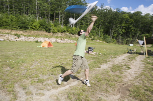 In this picture the plane is being launched. This particular Easy Star is set up with a larger electric motor to support the added camera weight. The heavy platform is now away from the original design and center of gravity. It is now more difficult to fly as a result, but remains highly maneuverable.
-Stewart
In this picture the plane is being launched. This particular Easy Star is set up with a larger electric motor to support the added camera weight. The heavy platform is now away from the original design and center of gravity. It is now more difficult to fly as a result, but remains highly maneuverable.
-Stewart
Cartographer notes
This map was somewhat challenging to create from the raw imagery. It was collected with a UAV and precision was quite low. The available base data is of low spatial resolution. The flight was cut short for safety reasons and it would have been nice if there were more raw images. -Stewart
Notes
While waiting for the rain to fully clear so we could go out on a larger balloon mapping expedition, we tested the Easy Star UAS platform. The site of the map is a beautiful piece of land in Eastern Kentucky that is looked after by Jim Wiley of wileyslastresort.com
In this picture the plane is being launched. This particular Easy Star is set up with a larger electric motor to support the added camera weight. The heavy platform is now away from the original design and center of gravity. It is now more difficult to fly as a result, but remains highly maneuverable.
-Stewart
Cartographer notes
This map was somewhat challenging to create from the raw imagery. It was collected with a UAV and precision was quite low. The available base data is of low spatial resolution. The flight was cut short for safety reasons and it would have been nice if there were more raw images. -Stewart
0 Comments
Login to comment.