
On December 5th representatives of New York State's Department of Environmental Conservation mentioned at a Water Quality public information meeting that New York City had notified them of a major sewage spill in the Gowanus Canal. This was a a result of storm damage from the Sandy floods, where salt flood waters flooded generators controlling sewer pump stations at Butler Street at the head of the Canal.
Entire sewer plants have been disabled as a result of the floods, with City and State authorities working round the clock to get them back online.
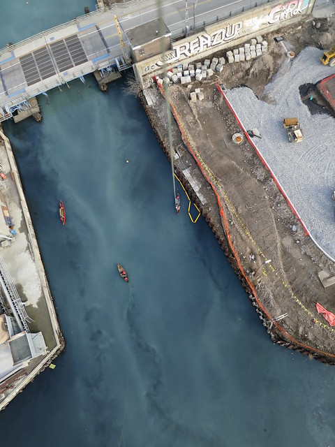
6 weeks after the flood, the Gowanus Canal Conservancy and the Gowanus Dredgers Canoe Club did their seasonal vegetation and water mapping of the Gowanus Canal.
It seems like the sewage is still actively flowing into the Canal:
You can view more pictures from the 15 December "Survey the Sludge" expedition here:
https://www.flickr.com/photos/51802375@N04/sets/72157629561924342/
The water quality monitoring images will allow local environmental quality groups, such as the Gowanus Dredgers Canoe Club to advocate for locating the vulnerable pumps above the flood zone to prevent these kinds of problems.
We used a Canon s100 GPS enabled camera, tethered to a helium weather balloon. The Canon s100, running a CHDK script for taking pictures every 10 seconds provided excellent image quality. However with the GPS tagging function on, we found that battery life was under 45 minutes, taking about 200 pics. To maximize our time on the water, we disabled the GPS function to minimize the hazards of swapping out of batteries in canoes while wrestling with a bouncy happy red balloon over sewage filled water.
3 Comments
This project was a lot of fun to participate in. Thanks PLOTS, Gowanus Canal Conservancy and Gowanus Dredgers Canoe Club for the balloon mapping day. I'll try and add my photos to the flickr account soon, or post a link to my own shared site.
Reply to this comment...
Log in to comment
Hi Jensta! We'd love to see your pictures! If you upload your pictures to your own Flickr site, and tag them "publiclaboratory", they will automatically be added to the stream that everyone sees, and when they click through they will see your account. Does that work? let me know if i can help. Liz
Is this a question? Click here to post it to the Questions page.
Reply to this comment...
Log in to comment
Hey Liz et al! Just posted my on-the-ground, survey the sludge photos from December 15th w/ the publiclaboratory tag on flickr: https://www.flickr.com/photos/jensta/. Thanks for the tagging tip!
Reply to this comment...
Log in to comment
Login to comment.