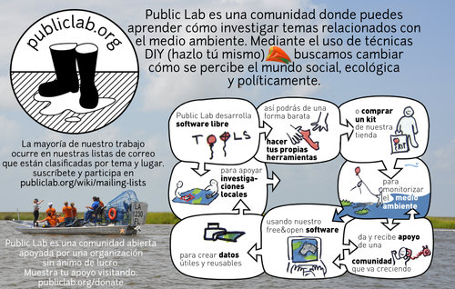
Home »
Places
Deepwater Horizon Oil Spill Mapping 2010-2011
Since May 2010, we have been using balloon mapping to capture aerial imagery of spill-affected sites in Louisiana, Mississippi, Alabama and Florida. Our work on the Gulf Coast in 2010, was done in cooperation with groups such as the Louisiana Bucket...
The New York / New Jersey / Pennsylvania metropolitan region is home to several projects with many partnering organizations, community groups, and individuals.
The Public Lab NYC community's mapping efforts are featured in Google Maps.
(Above: a plume discovered with near-infrared balloon...
Future Events
The following event was postponed and will be rescheduled for mid to late August. Please contact me if you plan to addend and have date preferences.
When: This Friday 7 June 2013 - gather between 9 and 10 AM - email/text/call me if you plan to come!
What to bring: Just you! If you...
Lima is home to a variety of initiatives and groups which share goals with Public Laboratory, and was the birthplace of the Grassroots Mapping project, which inspired Public Laboratory.
See the attached PDF article in America's Quarterly published in July 2012.
Collaborators: Digital+Media: Environmental Justice Research Cluster at the Rhode Island School of Design, AS220 and Environmental Justice League
Organized by Sara Wylie, RISD Students and Graduates Jae Ok Lee, Byeongwon Ha, Kyuha Shim and Mara Streberger, James Schaffroth, Megan McLaughlin and...
Grassroots Mapping hosts workshops in Portland in collaboration with Pacific Northwest College of Art, Reed College, Gallery Homeland, and Research Club, focusing on Balloon construction techniques and aerial photography.
PLOTS member Mathew Lippincott lives in Portland and is pursuing kite...
Our work in Somerville is developing in partnership with Parts and Crafts. Somerville is also home to Sprout and the Boston-area Dorkbot chapter.
The Public Laboratory chapter in Somerville is currently hosted out of the p.irateship, a coworking and hacking space at 438 Somerville Ave -- but folks...
A Public Laboratory group is just starting up in Texas, read below for more information and to get involved!
Current Activities:
At Occupy Austin, we have spun up a working group devoted to building both balloon/dirigible and quadcopter platforms for protest mapping and livestreaming. This effort...
Written by Elizabeth Wolf, Fundación Ciudadano Inteligente
The recent months of 2011 have marked the manifestation of student frustration with the Chilean education system. Hundreds of thousands of university and secondary students have flooded the streets of Santiago and other cities across...
Butte, Montana
Bert Mooney Airport (BTM)
Where I-90 & I-15 intersect:
119 miles east of Missoula on I-90, 85 miles west of Bozeman, MT on I-90
67 miles south of Helena, MT on I-15, 65 miles north of Dillon, MT on I-15
Major Landscape Features:
-The Continental Divide
-Silver Bow Creek/ Butte...
View the area that activists are currently working at: http://maps.google.com/maps?q=Modrava,+Czech+Republic&hl=en&sll=37.0625,...
Sumava is the biggest and strictly protected natural park in the Czech Republic. It has had to repeatedly face attacks on its strict level of ecosystem...
Vers?o em portugu?s:
O UNICEF em parceria com o Public Laboratory for Open Technology and Science (PLOTS) realizou um workshop pioneiro na ?rea de tecnologia de mapeamento comunit?rio com foco na preven??o de desastres, no Rio de Janeiro, entre os dias 22 a 26 de agosto. A comunidade piloto...
Public Laboratory working with interested members of the STS community around UCD in Davis, California. We are trying to reach out to interested folks and find some local issues to focus on.
http://keckcaves.org/
http://sts.ucdavis.edu/
Getting Started
Folks at the University of California Davis (...
Mildmay is a an area within the Borough of Islington in London, UK. The Mildmay Community Centre (MCC), which is located in Mildmay is "a community regeneration organisation and was established to predominantly but not exclusively be of benefit to the inhabitants of Mildmay in the Borough of...
Hosted by Andy Guest State Park over the weekend of 21-22 JUL 2012
Coordinated by Denizen Media and the Public Laboratory
This workshop represents the launching of a Shenandoah River image mapping project by Denizen Media and its director, Beverly Pearce. She has kits for loan and invites...
A Public Laboratory chapter is just starting up in Sweden. For now it is primarily students from Lund University to work with aerial mapping and mapping procedures. Read below for more information and to get involved!
Ola H [lejonbergatgmail.com]
Join the Skane [listserve] (https://groups.google....
Above: Early experiments in Vermont with the Public Lab's infrared camera tool.
.
PLOTS organizers Chris Fastie and Ned Horning are involved in multispectral imaging hardware, multispectral image processing, control and monitoring of airborne cameras, agricultural and vegetation mapping and...
Activity
-
On Jun 18, The creator of [GrassrootsMapping.org](http://grassrootsmapping.org) and co-founder and Research Director for the Public Laboratory for Open Technology and Science, Jeff designs mapping and civic science tools and professionally flies balloons and kites. Notable software he has created include [the vector-mapping framework Cartagen](http://cartagen.org) and [orthorectification tool MapKnitter](http://mapknitter.org), as well as open spectral database and toolkit [Spectral Workbench](http://spectralworkbench.org). He is a fellow at MIT's [Center for Civic Media](http://civic.mit.edu), on the advisory board of [Personal Democracy Media's WeGov](http://techpresident.com/topics/wegov) and an advocate of open source software, hardware, and data. He co-founded Vestal Design, a graphic/interaction design firm in 2004, and directed the Cut&Paste Labs project, a year-long series of workshops on opensource tools and web design in 2006-7 with Lima designer Diego Rotalde. Jeff holds an MS from MIT and a BA in Architecture from Yale University, and spent much of that time working with artist/technologist Natalie Jeremijenko, building robotic dogs and stuff. To find out more, visit Unterbahn.com. * https://github.com/jywarren * http://unterbahn.com * http://unterbahn.com/thesis/ updated Page: About Public Lab
-
Adam-Griffith commented on Adam-Griffith's Note "Folly Beach, SC - a detailed look at a $3 million beach "restoration"" on Jun Tuesday
-
Adam-Griffith commented on scaramel's Note "Video: Kitemappers" on Jun Tuesday
-
On Jun 13, Caterina Scaramelli created a new Note: Video: Kitemappers
-
On Jun 12, Stewart Long updated Map: Rotsoord. Utrecht, Netherlands.
-
On Jun 12, Stewart Long updated Map: Rotsoord. Utrecht, Netherlands.
-
On Jun 12, Stewart Long updated Map: Rotsoord. Utrecht, Netherlands.
-
On Jun 12, Hagit Keysar updated Page: MapKnitter Help
-
sonofaquark commented on sonofaquark's Note "Pascal's Wager" on Jun Wednesday
-
On Jun 10, www.quiviracoalition.org created a new Note: Test 1
-
On Jun 9, Shannon created a new Note: Public Lab community newsletter 6.9.13
-
tomh4236 commented on nedhorning's Note "Canon A2200 NIR conversion" on Jun Wednesday
-
On Jun 5, Adam D. Griffith is the Director of the Rivercane Restoration Project through the Program for the Study of Developed Shorelines (PSDS) at Western Carolina University. He received a BS degree in Biology from Roanoke College in 1999 (Omicron Delta Kappa) and was subsequently accepted to Teach for America. He taught 6th grade science in the Houston Independent School District in Texas for three years before becoming a kayak instructor taking him on numerous trips to the beaches of the United States, Panama, and Europe. He received his MS degree in Biology from Western Carolina University in 2008 studying the native bamboo Arundinaria gigantea. Since 2008, he has been a research scientist at PSDS where he launched coastalcare.org with the Santa Aguilla Foundation. He currently directs the communities and sea-level rise research. In 2011, he co-founded the Public Laboratory with 6 others by securing a $500,000 grant from the James S. and John L. Knight Foundation. As a result, his writings can be found on the PBS IdeaLab blog, publiclaboratory.org, and others. He has presented his research with the Public Laboratory across the United States, Mexico, and Europe. Selected Publications Tanner, B.R., Kinner, D.A., Griffith, A.D., Young, R.S. & Sorrell, L.M (2011). Presence of Arundinaria gigantea (river cane) on numerous non-wetland sites suggests improper ecological classification of the species. Wetlands Ecology and Management. 19(6): 521-532. Coburn, A.S., Griffith, A.D. & Young, R.S. (2010). Inventory of coastal engineering projects in coastal national parks. Natural Resource Technical Report NPS/NRPC/GRD/NRTR???2010/373. National Park Service, Fort Collins, Colorado. Griffith, A.D., Kinner, D.A., Tanner, B.R., Moore, A., Mathews, K.G. & Young, R.S. (2009). Nutrient and physical soil characteristics of rivercane (Arundinaria gigantea) stands, western North Carolina. Castanea. 74(3): 224-235. updated Page: Classification
-
dan.beavers commented on patcoyle's Note "Prototype juice bottle rig on R-10 UAir quad" on Jun Wednesday
-
On Jun 4, Stewart Long updated Map: Montgomery Bell State Park. Burns, Tennessee
-
On Jun 4, Stewart Long created a new Map: Montgomery Bell State Park
-
On Jun 4, Stewart Long updated Map: Rotsoord. Utrecht, Netherlands.
-
On Jun 4, Stewart Long created a new Map: Rotsoord. Utrecht, Netherlands.
-
On Jun 4, Stewart Long updated Map: Washington Crossing, Pennsylvania.
-
On Jun 4, Stewart Long created a new Map: Washington Crossing, Pennsylvania.

