Mapping Curriculum: Ground Control Point Targets
As part of the Grassroots Mapping Curriculum series.
Sometimes the scenes you create with photos from your balloon or kite can't be referenced to existing georeferenced imagery. For example, the scale of your photos may be too different (often a much larger geographic scale than commonly available imagery), or your imaged don't match the time scale of the the available reference imagery (such as the last available photo was taken five years ago and too much has changed). To remedy the problem of not having useful reference imagery to reference your photos to, you can make your own targets that will be clearly visible in your photos, and mark the center of the target with a GPS device. Then, rather than matching your photos to a reference image, you can use a georefereing program (like the georeferencing plug-in for Quantum GIS) to match your targets with the locations you marked with the GPS.
-Michele Tobias
These fabric ground control points are durable, reusable, and easily visible from high altitude. At low altitudes where ground features may not be distinguishable, it may be useful to make paper coded ground control points.
Materials & Tools:
- Fabric – something sturdy like nylon
- Ribbon – make sure it contrasts well with the fabric
- Thread
- Sewing Machine (or needle if you want to sew it by hand)
- Thin Bias Tape or Ribbon (optional) – for making corner loops
Steps:
- 1. Pick a size for your targets. You need to make them big enough to see in the photos but not so large that they cover important things.
- 2. Choose your fabric and ribbon. Consider bringing your cameras (color and infrared) to the fabric store to take test photos to make sure that the fabric and ribbon have a high degree of contrast in all the wavelengths you care about.
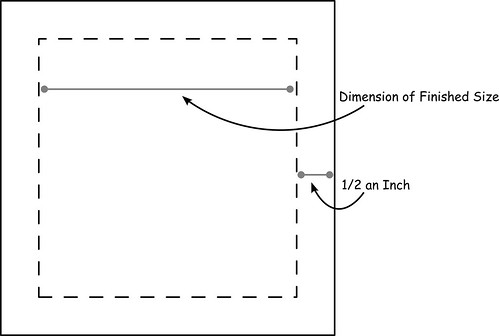
- 3. Make a pattern/template out of scrap paper (newspaper works great): take the dimensions you want for your finished target (the size you picked in Step 1), then add half an inch to each side (this leaves room to hem the edges and prevent fraying).
- 4. Place your pattern on the fabric (pin it in place if you want), and cut around it.
- 5. Cut two lengths of ribbon to the width of your pattern.
- 6. Pin the ribbons, crossed, on your fabric square.
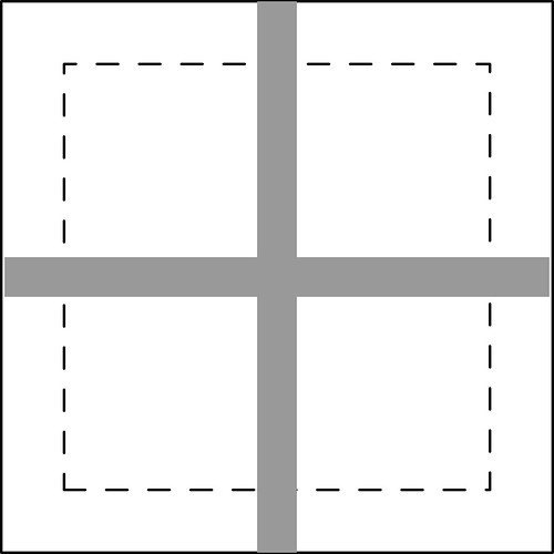
- 7. Sew the edges of the ribbon onto the fabric. A zig-zag stitch is useful here.
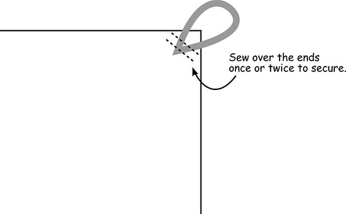
- 8. Turn the target over so the ribbon side is down. Fold the edge of each side of the target over 1/4 of an inch, then again 1/4 of an inch. You may want to iron the fold to help it stay folded. Pin the folds down so they stay in place. Now sew over all the edges you folded.
Optional Steps:
- 9. You can make loops on the corners of the squares by sewing loops of bias tape or thin ribbon to each corner. This allows you to put a stake through the loop to keep it from blowing away.
- 10. Use left-over pieces of ribbon to make identifying marks on your targets so they are easy to identify later. You could make numbers, or increasing numbers of dots, for example.
What links here
Activity
-
On Jun 18, The creator of [GrassrootsMapping.org](http://grassrootsmapping.org) and co-founder and Research Director for the Public Laboratory for Open Technology and Science, Jeff designs mapping and civic science tools and professionally flies balloons and kites. Notable software he has created include [the vector-mapping framework Cartagen](http://cartagen.org) and [orthorectification tool MapKnitter](http://mapknitter.org), as well as open spectral database and toolkit [Spectral Workbench](http://spectralworkbench.org). He is a fellow at MIT's [Center for Civic Media](http://civic.mit.edu), on the advisory board of [Personal Democracy Media's WeGov](http://techpresident.com/topics/wegov) and an advocate of open source software, hardware, and data. He co-founded Vestal Design, a graphic/interaction design firm in 2004, and directed the Cut&Paste Labs project, a year-long series of workshops on opensource tools and web design in 2006-7 with Lima designer Diego Rotalde. Jeff holds an MS from MIT and a BA in Architecture from Yale University, and spent much of that time working with artist/technologist Natalie Jeremijenko, building robotic dogs and stuff. To find out more, visit Unterbahn.com. * https://github.com/jywarren * http://unterbahn.com * http://unterbahn.com/thesis/ updated Page: About Public Lab
-
Adam-Griffith commented on Adam-Griffith's Note "Folly Beach, SC - a detailed look at a $3 million beach "restoration"" on Jun Tuesday
-
Adam-Griffith commented on scaramel's Note "Video: Kitemappers" on Jun Tuesday
-
On Jun 13, Caterina Scaramelli created a new Note: Video: Kitemappers
-
On Jun 12, Stewart Long updated Map: Rotsoord. Utrecht, Netherlands.
-
On Jun 12, Stewart Long updated Map: Rotsoord. Utrecht, Netherlands.
-
On Jun 12, Stewart Long updated Map: Rotsoord. Utrecht, Netherlands.
-
On Jun 12, Hagit Keysar updated Page: MapKnitter Help
-
sonofaquark commented on sonofaquark's Note "Pascal's Wager" on Jun Wednesday
-
On Jun 10, www.quiviracoalition.org created a new Note: Test 1
-
On Jun 9, Shannon created a new Note: Public Lab community newsletter 6.9.13
-
tomh4236 commented on nedhorning's Note "Canon A2200 NIR conversion" on Jun Wednesday
-
On Jun 5, Adam D. Griffith is the Director of the Rivercane Restoration Project through the Program for the Study of Developed Shorelines (PSDS) at Western Carolina University. He received a BS degree in Biology from Roanoke College in 1999 (Omicron Delta Kappa) and was subsequently accepted to Teach for America. He taught 6th grade science in the Houston Independent School District in Texas for three years before becoming a kayak instructor taking him on numerous trips to the beaches of the United States, Panama, and Europe. He received his MS degree in Biology from Western Carolina University in 2008 studying the native bamboo Arundinaria gigantea. Since 2008, he has been a research scientist at PSDS where he launched coastalcare.org with the Santa Aguilla Foundation. He currently directs the communities and sea-level rise research. In 2011, he co-founded the Public Laboratory with 6 others by securing a $500,000 grant from the James S. and John L. Knight Foundation. As a result, his writings can be found on the PBS IdeaLab blog, publiclaboratory.org, and others. He has presented his research with the Public Laboratory across the United States, Mexico, and Europe. Selected Publications Tanner, B.R., Kinner, D.A., Griffith, A.D., Young, R.S. & Sorrell, L.M (2011). Presence of Arundinaria gigantea (river cane) on numerous non-wetland sites suggests improper ecological classification of the species. Wetlands Ecology and Management. 19(6): 521-532. Coburn, A.S., Griffith, A.D. & Young, R.S. (2010). Inventory of coastal engineering projects in coastal national parks. Natural Resource Technical Report NPS/NRPC/GRD/NRTR???2010/373. National Park Service, Fort Collins, Colorado. Griffith, A.D., Kinner, D.A., Tanner, B.R., Moore, A., Mathews, K.G. & Young, R.S. (2009). Nutrient and physical soil characteristics of rivercane (Arundinaria gigantea) stands, western North Carolina. Castanea. 74(3): 224-235. updated Page: Classification
-
dan.beavers commented on patcoyle's Note "Prototype juice bottle rig on R-10 UAir quad" on Jun Wednesday
-
On Jun 4, Stewart Long updated Map: Montgomery Bell State Park. Burns, Tennessee
-
On Jun 4, Stewart Long created a new Map: Montgomery Bell State Park
-
On Jun 4, Stewart Long updated Map: Rotsoord. Utrecht, Netherlands.
-
On Jun 4, Stewart Long created a new Map: Rotsoord. Utrecht, Netherlands.
-
On Jun 4, Stewart Long updated Map: Washington Crossing, Pennsylvania.
-
On Jun 4, Stewart Long created a new Map: Washington Crossing, Pennsylvania.


