Hydrogen Balloons
Why Hydrogen?
With Helium being expensive and now subject to shortage, many people are looking for more available and inexpensive alternatives. Hydrogen is the only gas providing lift similar to helium, in fact, it provides about 7-8% more lift.Hydrogen is widely used in atmospheric sounding balloons outside North America.
Methane, the other gas historically used for balloons provides less than 48% of the lift of Helium, and has 3.75 times the energy density, making it far more dangerous than hydrogen in the event of a fire. Hot air, depending on temperature, provides only 5-15% of the lift of helium.
Safety
Hydrogen burns, and can be ignited by open flame and static electricity. Here is what a five foot balloon looks like when it catches fire, note that the fallout from the burning rubber appears more dangerous than the hydrogen itself.
From Launch PSU, at Portland State:
Electrolysis of Hydrogen
Chemical Generation of Hydrogen
Hydrogen generation test at NuVuWorkshop
Here's our basic setup, just to measure hydrogen volume output. Aluminum and lye (in water) are mixed in the test tube, hydrogen is pushed out the tube into the bottom of the flask on the left. The flask is filled with water so it cools any water vapor (the reaction is exothermic and produces steam) so that the balloon is filled only with hydrogen (plus a little air that was in the system already).
Safety
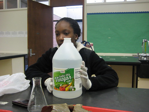
Lye is caustic and quite dangerous if exposed to skin or eyes. If you touch it, flush with water then vinegar or another weak acid. Use rubber gloves and eye protection.
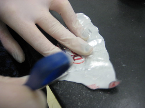
Aluminum cans are coated in plastic, so to get things going you can scrape it off with scissors or a knife.
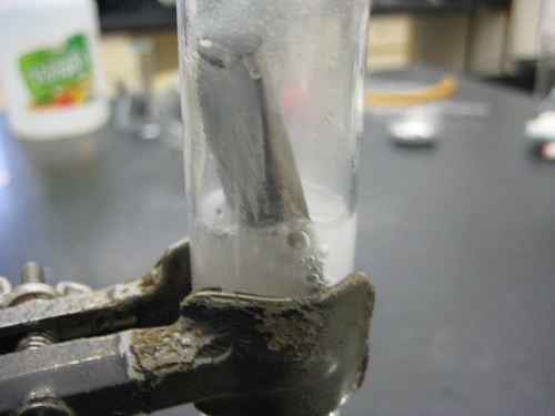
We dropped in some aluminum and stoppered the test tube. It began bubbling a bit immediately.
Hydrogen coming out in the bubbler.
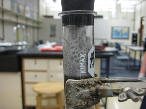
Here the reaction is really going strong. Our exit tube was too narrow and the stopper popped off from the built-up pressure. Exciting.
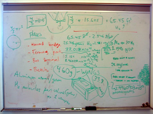
Here's our calculation (illegible) of how many grams of aluminum produce enough hydrogen to fill a 5-foot balloon (sphere). I think this is wrong; we assumed Al2, not Al.
We calculated 33.8 aluminum cans (at 13.6 grams each). We didn't get to confirm the result.
What links here
Activity
-
On May 17, The creator of [GrassrootsMapping.org](http://grassrootsmapping.org) and co-founder and Research Director for the Public Laboratory for Open Technology and Science, Jeff designs mapping and civic science tools and professionally flies balloons and kites. Notable software he has created include [the vector-mapping framework Cartagen](http://cartagen.org) and [orthorectification tool MapKnitter](http://mapknitter.org), as well as open spectral database and toolkit [Spectral Workbench](http://spectralworkbench.org). He is a fellow at MIT's [Center for Civic Media](http://civic.mit.edu), on the advisory board of [Personal Democracy Media's WeGov](http://techpresident.com/topics/wegov) and an advocate of open source software, hardware, and data. He co-founded Vestal Design, a graphic/interaction design firm in 2004, and directed the Cut&Paste Labs project, a year-long series of workshops on opensource tools and web design in 2006-7 with Lima designer Diego Rotalde. Jeff holds an MS from MIT and a BA in Architecture from Yale University, and spent much of that time working with artist/technologist Natalie Jeremijenko, building robotic dogs and stuff. To find out more, visit Unterbahn.com. * https://github.com/jywarren * http://unterbahn.com * http://unterbahn.com/thesis/ updated Tool: Near-Infrared Camera
-
mathew commented on mathew's Note "Pole photography" on May Friday
-
On May 16, Shannon updated Note: Tool for Stalling: Mapping
-
Adam-Griffith commented on Adam-Griffith's Note "Folly Beach, SC - a detailed look at a $3 million beach "restoration"" on May Wednesday
-
On May 14, dridaycreromi updated Note: Folly Beach, SC - a detailed look at a $3 million beach "restoration"
-
On May 14, dridaycreromi created a new Note: Folly Beach, SC - a detailed look at a $3 million beach "restoration"
-
On May 13, The creator of [GrassrootsMapping.org](http://grassrootsmapping.org) and co-founder and Research Director for the Public Laboratory for Open Technology and Science, Jeff designs mapping and civic science tools and professionally flies balloons and kites. Notable software he has created include [the vector-mapping framework Cartagen](http://cartagen.org) and [orthorectification tool MapKnitter](http://mapknitter.org), as well as open spectral database and toolkit [Spectral Workbench](http://spectralworkbench.org). He is a fellow at MIT's [Center for Civic Media](http://civic.mit.edu), on the advisory board of [Personal Democracy Media's WeGov](http://techpresident.com/topics/wegov) and an advocate of open source software, hardware, and data. He co-founded Vestal Design, a graphic/interaction design firm in 2004, and directed the Cut&Paste Labs project, a year-long series of workshops on opensource tools and web design in 2006-7 with Lima designer Diego Rotalde. Jeff holds an MS from MIT and a BA in Architecture from Yale University, and spent much of that time working with artist/technologist Natalie Jeremijenko, building robotic dogs and stuff. To find out more, visit Unterbahn.com. * https://github.com/jywarren * http://unterbahn.com * http://unterbahn.com/thesis/ updated Note: Help requested with mapknitter- Balloon mapping of Metal processing plant in Providence, RI
-
On May 13, The creator of [GrassrootsMapping.org](http://grassrootsmapping.org) and co-founder and Research Director for the Public Laboratory for Open Technology and Science, Jeff designs mapping and civic science tools and professionally flies balloons and kites. Notable software he has created include [the vector-mapping framework Cartagen](http://cartagen.org) and [orthorectification tool MapKnitter](http://mapknitter.org), as well as open spectral database and toolkit [Spectral Workbench](http://spectralworkbench.org). He is a fellow at MIT's [Center for Civic Media](http://civic.mit.edu), on the advisory board of [Personal Democracy Media's WeGov](http://techpresident.com/topics/wegov) and an advocate of open source software, hardware, and data. He co-founded Vestal Design, a graphic/interaction design firm in 2004, and directed the Cut&Paste Labs project, a year-long series of workshops on opensource tools and web design in 2006-7 with Lima designer Diego Rotalde. Jeff holds an MS from MIT and a BA in Architecture from Yale University, and spent much of that time working with artist/technologist Natalie Jeremijenko, building robotic dogs and stuff. To find out more, visit Unterbahn.com. * https://github.com/jywarren * http://unterbahn.com * http://unterbahn.com/thesis/ updated Note: Public Lab NorCal Meetup Fort Mason San Francisco CA
-
nedhorning commented on John_Wells's Note "The Scottish National Aerial Photography Scheme" on May Monday
-
On May 13, The creator of [GrassrootsMapping.org](http://grassrootsmapping.org) and co-founder and Research Director for the Public Laboratory for Open Technology and Science, Jeff designs mapping and civic science tools and professionally flies balloons and kites. Notable software he has created include [the vector-mapping framework Cartagen](http://cartagen.org) and [orthorectification tool MapKnitter](http://mapknitter.org), as well as open spectral database and toolkit [Spectral Workbench](http://spectralworkbench.org). He is a fellow at MIT's [Center for Civic Media](http://civic.mit.edu), on the advisory board of [Personal Democracy Media's WeGov](http://techpresident.com/topics/wegov) and an advocate of open source software, hardware, and data. He co-founded Vestal Design, a graphic/interaction design firm in 2004, and directed the Cut&Paste Labs project, a year-long series of workshops on opensource tools and web design in 2006-7 with Lima designer Diego Rotalde. Jeff holds an MS from MIT and a BA in Architecture from Yale University, and spent much of that time working with artist/technologist Natalie Jeremijenko, building robotic dogs and stuff. To find out more, visit Unterbahn.com. * https://github.com/jywarren * http://unterbahn.com * http://unterbahn.com/thesis/ updated Note: The Scottish National Aerial Photography Scheme
-
ives commented on GroundworkNola's Note "Youth Mapping Experiences" on May Sunday
-
PlanetenPaultje commented on cfastie's Note "Invisible Rays" on May Sunday
-
On May 11, Patrick Coyle updated Note: Public Lab NorCal Meetup Fort Mason San Francisco CA
-
patcoyle commented on cfastie's Note "Invisible Rays" on May Saturday
-
On May 10, Lynn Reale Wolbarst created a new Note: Help requested with mapknitter- Balloon mapping of Metal processing plant in Providence, RI
-
On May 9, Stewart Long updated Note: MapKnitter: forcing layer order through larger scale images
-
On May 9, Stewart Long updated Map: SFSU San Francisco, California.


