Image Analysis

Infrared compositing
If you have near-infrared imagery you can composite that imagery with the visible-light imagery to see how healthy the vegetation is.
- NDVI and NRG compositing
- Video: Creating infrared composites of aerial wetlands imagery - Learn to combine infrared and visible-light photographs (taken from balloon photography) to produce an "NRG" composite, where reddish color indicates photosynthesis.
- Video: Creating false-color NDVI with aerial wetlands imagery - Learn to use the open-source GIMP application to create a Normalized Differential Vegetation Index image from infrared and visible-light aerial photographs. Also explore false-color techniques for presenting the data.

Contrast adjustments
Stretch the contrast and saturation of your images to see more detail, especially underwater. Read more here:
Decorrelation stretching
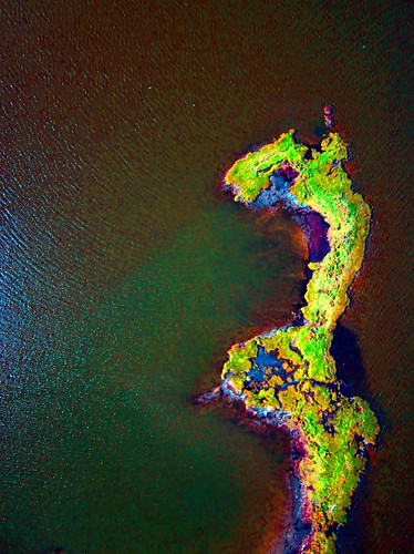
Nathan Craig writes: Decorrelation stretching may be a method to consider. Various flavors of the transformation are easily run using the DStretch Plugin for Image J. Several that seemed to represent variability relevant to the case study are included. I use DStretch to help bring out detail in rock art scenes that are highly eroded. However, the method has utility outside of rock art studies. It may be an additional approach to consider when trying to identify pollution or other contaminants.
Here is information on DStretch http://www.dstretch.com/
Here is a paper that describes the transformation http://eospso.gsfc.nasa.gov/eos_homepage/for_scientists/atbd/docs/ASTER/atbd-ast-06.pdf
Classification
Using the ratios of Red, Green, and Blue (and possibly Near-infrared), spectral classification attempts to categorize regions of an image by land type.
Read more on the classification page »
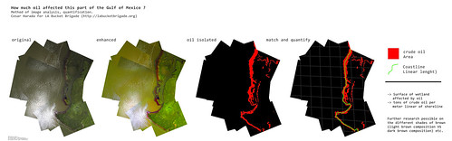

Image Analysis
| Purpose | Category | Status | Author | Time | Difficulty | Replications |
|---|---|---|---|---|---|---|
| How to download and analyze Landsat imagery | - | - | @donblair | - | - | 1 replications: Try it » |
| Use Image Sequencer for NDVI plant analysis with 2 images | - | - | @warren | - | - | 0 replications: Try it » |
| Case Study: Using Aerial Imagery to Pressure Industrial Polluters into Stormwater Compliance | - | - | @gretchengehrke | - | - | 0 replications: Try it » |
| Quantify wetland from aerial UV photo | - | - | @cesarharada | - | - | 0 replications: Try it » |
| Using multispectral imagery to derive bathymetry | - | - | @warren | - | - | 0 replications: Try it » |
Activities should include a materials list, costs and a step-by-step guide to construction with photos. Learn what makes a good activity here.