MapKnitter
Part of the Grassroots Mapping Curriculum series.
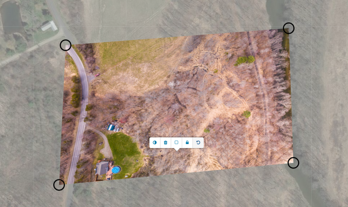
Creating a map from a set of aerial photos
Learn to turn aerial images into maps with the Public laboratory's open source MapKnitter.org tool. Upload an image, rotate, distort and stretch it onto a reference map, and use the transparency and outline modes to check how close the fit is. Then export to GeoTiff or OpenLayers/TMS.
MapKnitter (MapKnitter.org) is a free and open source tool for combining and positioning images (often from MapMill.org) in geographic space into a composite image map. Known as “orthorectification” or “georectification” to geographers, this step covers the process of figuring out where images can be placed on an existing map, and how they can be combined, or “stitched” together. You are likely to have many images of overlapping or identical areas, which is why MapMill or some type of sorting is used to determine which source images to use from the original set.
Background
MapKnitter can make maps from any image source, but it particularly lends itself to making maps with balloons and kites. The manual process of making maps with MapKnitter differs greatly from automated aerial imaging systems. In those systems the imaging is of a higher precision and processed with spatial and telemetry data collected along with the imagery, typically at higher altitudes and with consistent image overlap in the flight path sequence.
With MapKnitter the cartographer dynamically places each image and selects which images to include in the mosaic. Although the approaches are similar in that they use some type of additional information (usually pre-existing imagery of a lower resolution) as a reference, and that they are bound to specific cartographic elements such as map scale and map projection.
Guides
Learn more about MapKnitter in this list of guides:
Advanced
- Decisions with distortions - Learn about the design process of stitching maps when images are highly distorted or include tall buildings. This tutorial is in Photoshop, but the techniques are applicable to MapKnitter as well.
- Infrared multispectral compositing (no video, in progress) Learn how to combine an infrared dataset with your map to assess photosynthesis. (Also: learn how to collect infrared imagery)
Upcoming tutorials
- Photoshop tutorials:
- Choosing a resolution
- Importing a base layer from google maps or another source
- Warping a difficult image with the mesh "warp" tool
- Turning a Photoshop-produced map into a GeoTiff using MapKnitter
What links here
Activity
-
On Jun 18, The creator of [GrassrootsMapping.org](http://grassrootsmapping.org) and co-founder and Research Director for the Public Laboratory for Open Technology and Science, Jeff designs mapping and civic science tools and professionally flies balloons and kites. Notable software he has created include [the vector-mapping framework Cartagen](http://cartagen.org) and [orthorectification tool MapKnitter](http://mapknitter.org), as well as open spectral database and toolkit [Spectral Workbench](http://spectralworkbench.org). He is a fellow at MIT's [Center for Civic Media](http://civic.mit.edu), on the advisory board of [Personal Democracy Media's WeGov](http://techpresident.com/topics/wegov) and an advocate of open source software, hardware, and data. He co-founded Vestal Design, a graphic/interaction design firm in 2004, and directed the Cut&Paste Labs project, a year-long series of workshops on opensource tools and web design in 2006-7 with Lima designer Diego Rotalde. Jeff holds an MS from MIT and a BA in Architecture from Yale University, and spent much of that time working with artist/technologist Natalie Jeremijenko, building robotic dogs and stuff. To find out more, visit Unterbahn.com. * https://github.com/jywarren * http://unterbahn.com * http://unterbahn.com/thesis/ updated Page: About Public Lab
-
Adam-Griffith commented on Adam-Griffith's Note "Folly Beach, SC - a detailed look at a $3 million beach "restoration"" on Jun Tuesday
-
Adam-Griffith commented on scaramel's Note "Video: Kitemappers" on Jun Tuesday
-
On Jun 13, Caterina Scaramelli created a new Note: Video: Kitemappers
-
On Jun 12, Stewart Long updated Map: Rotsoord. Utrecht, Netherlands.
-
On Jun 12, Stewart Long updated Map: Rotsoord. Utrecht, Netherlands.
-
On Jun 12, Stewart Long updated Map: Rotsoord. Utrecht, Netherlands.
-
On Jun 12, Hagit Keysar updated Page: MapKnitter Help
-
sonofaquark commented on sonofaquark's Note "Pascal's Wager" on Jun Wednesday
-
On Jun 10, www.quiviracoalition.org created a new Note: Test 1
-
On Jun 9, Shannon created a new Note: Public Lab community newsletter 6.9.13
-
tomh4236 commented on nedhorning's Note "Canon A2200 NIR conversion" on Jun Wednesday
-
On Jun 5, Adam D. Griffith is the Director of the Rivercane Restoration Project through the Program for the Study of Developed Shorelines (PSDS) at Western Carolina University. He received a BS degree in Biology from Roanoke College in 1999 (Omicron Delta Kappa) and was subsequently accepted to Teach for America. He taught 6th grade science in the Houston Independent School District in Texas for three years before becoming a kayak instructor taking him on numerous trips to the beaches of the United States, Panama, and Europe. He received his MS degree in Biology from Western Carolina University in 2008 studying the native bamboo Arundinaria gigantea. Since 2008, he has been a research scientist at PSDS where he launched coastalcare.org with the Santa Aguilla Foundation. He currently directs the communities and sea-level rise research. In 2011, he co-founded the Public Laboratory with 6 others by securing a $500,000 grant from the James S. and John L. Knight Foundation. As a result, his writings can be found on the PBS IdeaLab blog, publiclaboratory.org, and others. He has presented his research with the Public Laboratory across the United States, Mexico, and Europe. Selected Publications Tanner, B.R., Kinner, D.A., Griffith, A.D., Young, R.S. & Sorrell, L.M (2011). Presence of Arundinaria gigantea (river cane) on numerous non-wetland sites suggests improper ecological classification of the species. Wetlands Ecology and Management. 19(6): 521-532. Coburn, A.S., Griffith, A.D. & Young, R.S. (2010). Inventory of coastal engineering projects in coastal national parks. Natural Resource Technical Report NPS/NRPC/GRD/NRTR???2010/373. National Park Service, Fort Collins, Colorado. Griffith, A.D., Kinner, D.A., Tanner, B.R., Moore, A., Mathews, K.G. & Young, R.S. (2009). Nutrient and physical soil characteristics of rivercane (Arundinaria gigantea) stands, western North Carolina. Castanea. 74(3): 224-235. updated Page: Classification
-
dan.beavers commented on patcoyle's Note "Prototype juice bottle rig on R-10 UAir quad" on Jun Wednesday
-
On Jun 4, Stewart Long updated Map: Montgomery Bell State Park. Burns, Tennessee
-
On Jun 4, Stewart Long created a new Map: Montgomery Bell State Park
-
On Jun 4, Stewart Long updated Map: Rotsoord. Utrecht, Netherlands.
-
On Jun 4, Stewart Long created a new Map: Rotsoord. Utrecht, Netherlands.
-
On Jun 4, Stewart Long updated Map: Washington Crossing, Pennsylvania.
-
On Jun 4, Stewart Long created a new Map: Washington Crossing, Pennsylvania.

