Incompatible browser

The Public Laboratory website will not render correctly in Internet Explorer 6 or earlier. To view it properly, please use an up-to-date browser, such as Firefox, Chrome, or another standards-compliant browser. It's a good idea to upgrade anyways -- olderversions of IE pose a security risk for your computer.

PLOTS Map Toolkit

As part of the Grassroots Mapping Curriculum series.

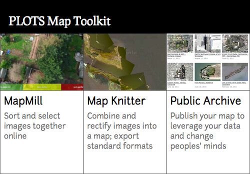
1) MapMill
About MapMill
2) MapKnitter map project creation
About MapKnitter
3) Map making with Knitter, adding local images, mapmill images
4) Export
5) Publish in the Public Laboratory archive.
- "Want to make a point with your map? Change peoples' minds, challenge the public's attitude about a place? Contact PLOTS staff to have your map featured in the PLOTS Archive."

PLOTS Map Toolkit 1.0

Release date: Sept 30
MapKnitter at GitHub

PLOTS Map Toolkit 2.0

Release date? 2012

  • x/y coordinate notes inside of maps
  • smartphone app?

Mapmill.org
currently in development:
wish list: https://github.com/jywarren/mapmill/issues
- exif data
- sort by time, sort by rank
-connection to /raw datasets for each map in the archive, upload once and done.

Knitter
currently in development: masking
wish list: https://github.com/jywarren/cartagen/issues
- rotate only, apart from rescale only
- activity notification (split second feedback, letting user know to wait for tool to complete current task)

Archive
currently in development:
wish list: connection to knitter, but how? export to archive?